
The Puyallup-White Local Integrating Organization (LIO) built on the existing success of the Puyallup Watershed Council by developing an Ecosystem Recovery Plan using a meaningful community-based process. This complex and dynamic landscape links urbanized Tacoma with the flanks of Mt. Rainier and was historically an agriculturally and forested productive landscape, stewarded by the Muckleshoot and Puyallup Tribes.
In the next 20 years, the area is expected to have 400,000 more residents, which will test the ability of the LIO and its partners to craft sustainable resilience strategies that accommodate that growth without severely damaging assets the community values- forests, farms, floodplains.
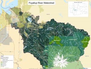
The Ecosystem Recovery Plan (ERP) has an assessment of the groups and plans operating in the region, a web-based representation of the ERP and a web-based (GIS) mapping tool intended to help collaborators and community groups identify priority areas for stewardship and focused attention. This web tool is accessible on any device (and has been optimized for mobile phones) and is also intended for use by the public. The ERP developed 8 focus areas, with climate change and equity and human well-being considered overarching, “blue cheese vein,” elements throughout the remaining six focus areas: Estuaries, Floodplains, Forests, Farms and Agricultural Land, Salmon and Stormwater/Water Quality.
Other products associated with the LIO include some very practical civic engagement tools that highlight how to get involved and positively influence policy. On a related note, our Stormwater SIL has been working with the South Central LIO on aligning and integrating salmon work—which tends to encompass watershed scale strategies—with stormwater interventions which tend to operate at a smaller site scale.
The GIS mapping tool is a great way to visually “assemble” multiple layers so users can see how different parts of a landscape interact with each other.
Why does this matter?
This geography is wildly diverse and is home to many important resources the community covets. By having an ecosystem-based plan, local collaborators can get a better sense of how all the “parts” fit together, and the mapping tool gives prioritization efforts some teeth. The Local Integrating Organizations, in consort with the Watershed Council, play an indispensable role in bringing together a wide range of businesses, non-profits, residents, and agencies in one “Venn” diagram, that they call call home.
If you want to get involved please send an email to PWR-LIO@rossstrategic.com
Owen Brummel and Heidi Siegelbaum