Integrated floodplain management is an emerging form of planning, action, and management where partners from a wide variety of sectors, including local jurisdictions, conservation districts, and representatives from agricultural industry, to name just a few, agree on a set of shared visions, strategies, and actions to improve floodplain health. Instead of competing against one another for limited resources, partners work together to pursue diverse funding opportunities and develop a suite of integrated projects that collectively moves stakeholders across the watershed closer to achieving their goals.
Local floodplain practitioners and leaders have been working together to find a new norm on how to manage floodplains. We now have a snapshot of this work, thanks to the Puget Sound Institute, which just completed a “Synthesis of Integrated Floodplain Management in Selected Puget Sound River Deltas.” The synthesis highlights Integrated Floodplain Management groups in the Nooksack, Samish, Skagit, Stillaguamish, Snoqualmie, and Snohomish river basins in the Puget Sound Region. These basins were selected based on their large area of historic contiguous habitat and their significance to local salmon recovery efforts.

Highlights of the Synthesis
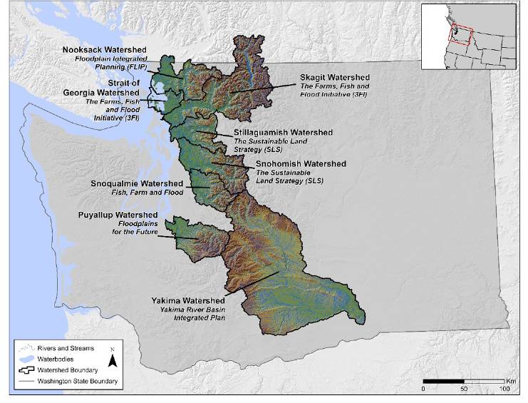
This synthesis compares the efforts of a selection of organizations, coalitions, processes, and groups in Puget Sound. These case studies focus on the following groups to demonstrate how they utilized integrated floodplain management principles and goals to meet their objectives. The selected groups include (presented in alphabetical order):
- Fish, Farm and Flood – operating in King County and focusing on the Snoqualmie River and tributaries
- Floodplain Integrated Planning (FLIP) – operating in Whatcom County and focusing on the Nooksack River and tributaries
- Sustainable Land Strategy (SLS) – operating primarily in Snohomish County and focusing on the Snohomish and Stillaguamish Rivers
- The Farm, Fish and Flood Initiative (3FI) – operating in Skagit County and focusing on the Skagit River and Samish River watershed

The geographic scope of the synthesis covered from the Nooksack Watershed in northern Washington to the Yakima Watershed.
We selected these basins based on their large area of historic contiguous habitat and their significance to local salmon recovery plans. While the synthesis focused on those groups operating within the five river basins, we included additional examples of groups utilizing whole watershed approaches to Integrated Floodplain Management – Floodplains for the Future, operating in the Puyallup River watershed, and the Yakima River Basin Integrated Plan, operating in the Yakima River Basin.
What did we learn?
The synthesis compares the integrated floodplain management organizations, groups and processes by exploring:
- The organizational structure, leadership, area and extent of operating geography,
- Who the major players are, including lead, consultants, stakeholders, and partners,
- The primary sources of funding,
- The organizations’ mission and values statements,
- The organizations’ Integrated Floodplain Management philosophy, stated objectives, goals, and principles,
- How the organization approaches integrated floodplain management to demonstrate levels of adoption, familiarity, and advancement of Integrated Floodplain Management principles
- Previously completed and ongoing projects that the organization or group has been involved

One of the purposes of this synthesis is to serve as a resource for Integrated Floodplain Management practitioners in Puget Sound, to support broader awareness and insights into Integrated Floodplain Management approaches, accomplishments, and challenges. By learning from Integrated Floodplain Management groups’ backgrounds, stakeholders and partners, mission and vision, goals and objectives, funding and current projects, floodplain practitioners and the Puget Sound recovery community can integrate their floodplain management strategies more effectively.
Did you know?
Floodplains and estuaries are dynamic and diverse landscapes that extend from the uppermost river reaches to the intertidal mudflats and salt marshes at the mouths of rivers entering Puget Sound. These habitats provide critical connections between terrestrial and aquatic systems, linking freshwater and marine processes. They have also been integral to Native Americans’ lives and cultural practices for millennia. The Floodplains and Estuaries Implementation Strategy describes the steps to accelerate progress towards Puget Sound recovery goals within each of these landscapes.
The Floodplains and Estuaries Implementation Strategy emphasizes the importance of developing and implementing a system that supports integrated floodplain management approaches within and across Puget Sound River basins, incorporating needs related to improving regional flood safety, expanding and improving upon critical areas of salmon habitat, and preserving and maintaining regional agricultural viability in Puget Sound.

