
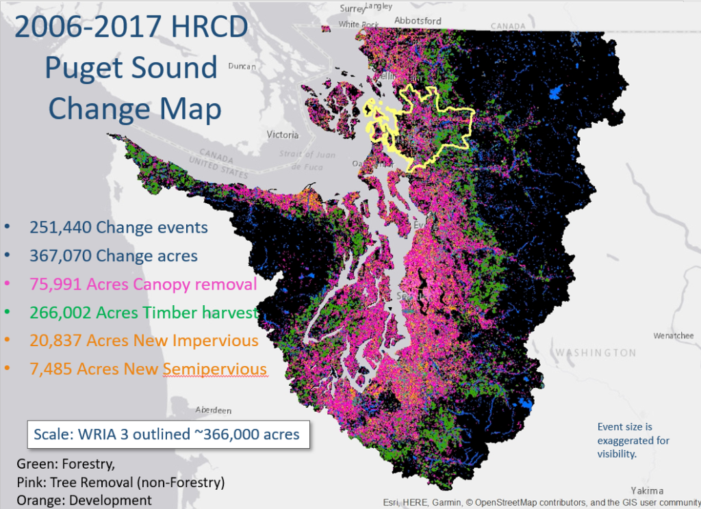
WDFW’s High Resolution Change Detection (HRCD) project has recently finished the 2015-2017 change data for the 19 WRIAs of Puget Sound. This completes the fifth time interval for HRCD going back to 2006. The project maps land cover change using repeatable methods and was found to be highly accurate as well as relevant to land management monitoring for conservation. The most recent project also included a digitized surface water layer and modeled tree canopy for the area with available data.
On September 11, 2020, the project lead, Dr. Kenneth Pierce with the Washington Department of Fish and Wildlife, presented an overview of the data and analyses to date as well as opportunities for different ways this information can be used for a variety of “land cover change” questions. The analysis includes estimates of riparian change for a simple region-wide 100’ buffer that incorporated the Statewide Integrated Fish Distribution data, HRCD change, new visible water and new canopy maps.
Potential Uses
Available to public users via the HRCD website, this data can be used to help inform a variety of questions related to land cover change over time. Because the dataset not only illustrates land cover change over time, but also includes locations of change, details on causes (Change Agents) and types (i.e. canopy loss, impervious surface gain), users could use the data to help answer policy or planning level questions.
Resources and Helpful Links
We have recorded the webinar [link here], and have documented a list of questions and answers from the presentation. You can find out more , including access to data and additional FAQs, at the HRCD Website. If you have trouble accessing the data you can contact the HRCD team for assistance at HRDC@dfw.wa.gov.
High Quality Video available for download
Additional Questions and Answers
Did you Know?
The Land Development and Cover Implementation Strategy is a road map for achieving some of the Vital Sign indicator targets. The work under this project tracks changes in land cover over time with accurate, high resolution spatial information to be used by local jurisdictions, state agencies, tribes and other organizations throughout Puget Sound. These datasets form the basis for tracking several new Puget Sound Vital Sign Indicators adopted by the Leadership Council in 2020 and has applications for all the Habitat Vital Signs.